Val di Fassa: what to see, do and where to stay

Trentino (TN) · 1,320 m a.s.l.

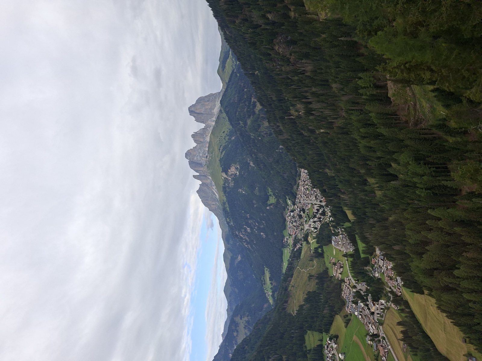
Canazei vista dall'alto, con il gruppo del Sassolungo sullo sfondo

Foto: Archivio leDolomiti.it

Val di Fassa follows the Avisio torrent through northern Trentino, with some of the best-loved massifs in the Dolomites on either side: the Catinaccio and its Gothic spires, the Sassolungo, the Sella, and at the far end the great bulk of the Marmolada. Seven towns sit one after another between 1,200 and 1,500 metres, from Moena, the so-called fairy of the Dolomites, up to Canazei and Campitello at the foot of the big passes. The valley has a warm, easygoing feel, where harsh rock sits next to soft meadows and busy little village centres.

It's the only valley in Trentino where Ladin is still in daily use, kept alive by the schools, the Istituto Culturale Ladino, and the Museum Ladin de Fascia in Vigo. And it's on these peaks that the legend of King Laurin and his rose garden is set. The story goes that the king, beaten in battle, cursed his roses so no one would ever see them again, by day or by night, and forgot the one hour of twilight. So the Catinaccio glows deep red as the sun goes down, the effect known as enrosadira.

In winter you ski the wide circuits of the Catinaccio and join the Sellaronda from Canazei and Campitello. In summer the valley turns into a base for via ferratas, trekking, and climbs toward the Torri del Vajolet and the Marmolada. There's a long spa tradition too, built around the mineral springs at Pozza, and a calendar packed with traditional festivals. The Fassans are proud of their cultural autonomy, and they've built the valley's name on tourism without letting it wipe out who they are.

When it is worth coming to Val di Fassa, month by month: When to Go to the Dolomites: A Month-by-Month Guide.

What to seeVal di Fassa

The Catinaccio glowing red at sunset, seen from Rifugio Bolzano on the Sciliar

Sight · Val di Fassa

Catinaccio e il Giardino delle Rose al tramonto

As the sun goes down, the walls of the Catinaccio turn from rose to fiery red. This is the enrosadira, the effect Ladin legend ties to King Laurino's cursed rose garden.

Le Torri del Vajolet e il rifugio nel gruppo del Catinaccio

Sight · Val di Fassa

Rifugio Vajolet e le Torri del Vajolet

Three near-vertical spires at the heart of the Catinaccio, with refuges at their feet that shaped climbing history, in one of the most dramatic rock amphitheatres in Val di Fassa.

I prati verdi della Val San Nicolò in Val di Fassa

Sight · Val di Fassa

Val San Nicolò

The best-loved side valley of Val di Fassa: a wide green basin of meadows, farmhouses and waterfalls behind Pozza, where you leave the car at the entrance and walk in the quiet.

VillagesVal di Fassa

See all
Val di Fassa seen from Canazei with the Dolomite peaks

Village · Val di Fassa · 1,465 m

Canazei

The village at the head of Val di Fassa, at the foot of the Sella and the Marmolada, a base for the Sellaronda and the Vajolet Towers.

Campitello di Fassa at the foot of the Sassolungo

Village · Val di Fassa · 1,442 m

Campitello di Fassa

A small village at the foot of the Sassolungo, with the cable car up to Col Rodella and a long history of mountain guides.

View of Moena at the entrance to Val di Fassa

Village · Val di Fassa · 1,184 m

Moena

The gateway to Val di Fassa, between Fiemme and Fassa, known as the Fairy of the Dolomites and for Puzzone di Moena cheese.

Pozza and Vigo di Fassa on the valley floor, seen from above between the forests

Village · Val di Fassa · 1,382 m

Vigo di Fassa

The historic and cultural heart of the Ladin valley, at the foot of the Catinaccio, home to the Ladin museum and cultural institute.

Pozza di Fassa seen from the Buffaure gondola

Village · Val di Fassa · 1,320 m

Pozza di Fassa

A village at the centre of the valley, now part of the Sèn Jan municipality, with the Buffaure gondola and the Alba spa waters.

Peaks, lakes and passes — Val di Fassa

The highest peaks near the villages

  • Punta Penia3,343 m7.7 km from Canazei
  • Gran Vernel3,210 m6.0 km from Canazei
  • Sassolungo3,181 m5.4 km from Campitello di Fassa
  • Piz Boè3,152 m5.6 km from Canazei
  • Punta Grohmann3,114 m3.9 km from Campitello di Fassa
  • Sasso Vernale3,058 m8.3 km from Canazei

The nearest lakes

  • Lago di Soraga1,210 m1.2 km from Moena
  • Lago Pian Da Mur2,056 m2.2 km from Canazei
  • Lago Secco2,360 m3.8 km from Pozza di Fassa
  • Lago di Antermoia2,508 m5.7 km from Pozza di Fassa
  • Lago di Mezzo1,608 m6.8 km from Moena
  • Lago di Lusia (superiore)2,384 m6.9 km from Moena

The nearest road passes

  • Passo Pordoi2,239 m3.4 km from Canazei
  • Passo Sella2,240 m3.5 km from Canazei
  • Passo di Costalunga1,745 m4.9 km from Moena
  • Passo Fedaia2,057 m7.2 km from Canazei
  • Passo Nigra1,690 m7.7 km from Vigo di Fassa

Straight-line distances from the nearest village in the valley. Elevations and names from OpenStreetMap, with peaks checked against the terrain model. See the area on the map of the Dolomites.

Nearby trailsVal di Fassa

See all

Mountain hutsVal di Fassa

Events in Val di Fassa

See all

When to go & weatherVal di Fassa

In winter, December to April, you ski the wide circuits of the Catinaccio and pick up the Sellaronda from Canazei and Campitello. In summer, June to September, it's via ferratas, trekking, and climbs toward the Marmolada and the Torri del Vajolet. The enrosadira, the red glow on the Catinaccio at sunset, is at its best on clear summer evenings. September brings cool air, still-green meadows, and traditional Ladin events like the transhumance re-enactments.

How to get thereVal di Fassa

From the north, come down from Val Gardena and Alta Badia over the Passo Sella, the Pordoi, or the Costalunga pass. From the south, climb up from Cavalese through the Val di Fiemme. On the A22, exit at Ora-Egna or Bolzano Sud and follow the Val d'Ega toward the Costalunga pass, past Lago di Carezza. The nearest rail station is Ora, linked to the valley by scheduled buses, and in season coaches and shuttles also run to Moena, Campitello, and Canazei. The valley spreads across seven towns between 1,200 and 1,500 metres, from Moena to Canazei.

Frequently asked questionsVal di Fassa

How many days do you need in Val di Fassa?

Three or four days are enough to climb to the Catinaccio, reach the Marmolada, and walk through Val San Nicolò. With a week you can add the Sellaronda, a via ferrata or two, and trips into the neighbouring valleys.

Is Val di Fassa suitable for families?

Yes. Val San Nicolò is an easy, gentle walk, and there are theme parks, scenic lifts, and kid-friendly mountain huts. Plenty of alpine dairies sit at the end of short walks that suit any age.

What is there to do in Val di Fassa on a rainy day?

Visit the Museum Ladin de Fascia, look in on the village workshops, or soak at the thermal spa in Pozza di Fassa. Bolzano or the nearby Val di Fiemme make a good day out if the rain stays.

How do you reach Val di Fassa without a car?

Take the train to Ora and carry on by scheduled bus up the valley to Moena, Canazei, and Campitello. In season there are direct services from the main airports too.

Which lakes are there in and around Val di Fassa?

Straight-line distance from the nearest village: Lago di Soraga (1,210 m, 1.2 km from Moena); Lago Pian Da Mur (2,056 m, 2.2 km from Canazei); Lago Secco (2,360 m, 3.8 km from Pozza di Fassa); Lago di Antermoia (2,508 m, 5.7 km from Pozza di Fassa); Lago di Mezzo (1,608 m, 6.8 km from Moena); Lago di Lusia (superiore) (2,384 m, 6.9 km from Moena). By road or on foot the way is longer.

Which mountain passes are there in and around Val di Fassa?

The nearest road passes, straight-line from the nearest village: Passo Pordoi (2,239 m, 3.4 km from Canazei); Passo Sella (2,240 m, 3.5 km from Canazei); Passo di Costalunga (1,745 m, 4.9 km from Moena); Passo Fedaia (2,057 m, 7.2 km from Canazei); Passo Nigra (1,690 m, 7.7 km from Vigo di Fassa).