
The Sciliar-Catinaccio Nature Park is the oldest of South Tyrol's seven nature parks: the Schlern area has been protected since 16 September 1974. It covers 7,288 hectares in the municipalities of Kastelruth (Castelrotto), Tiers (Tires) and Völs am Schlern (Fiè allo Sciliar). In German it is the Naturpark Schlern-Rosengarten.
It protects two very different mountains. The Schlern is one single block, with the Santner and Euringer towers on its corner: local people call it the mountain of destiny. The Rosengarten is the opposite, a thicket of spires, and it holds the Catinaccio d'Antermoia (Kesselkogel), 3,002 metres, the highest figure the Province names inside the park. The woods around Seis, Völs and Tiers and the Tschamin valley also belong to the protected area.
Here you will find the figures, how the landscape is built, where to enter and the rule that matters most here: driving access. The rules common to every Dolomite park are in our guide to the nature parks of the Dolomites.
A park created to stop the diggers
The other Dolomite parks were created to protect wild country. This one came out of a fight. In the early 1970s, the Province writes, the Seiser Alm had already moved from skiing pioneers to the first lift cables, and people had taken over the plateau in a short time. The landscape plan for the Seiser Alm put on the first brake: limits on traffic and building, and the decision to create the Province's first nature park.
It was not a popular decision. Farmers feared that limits on use would threaten their survival, hunters that they would lose their game, the tourist industry saw plans for new lifts collapse, and hoteliers feared their guests would go elsewhere. The Schlern area was protected all the same, on 16 September 1974.
Today's name is more recent. On 14 September 2003, the Seiser Alm tourist board recalls, the park was extended to the Rosengarten massif: since then it has carried both names, and its 7,288 hectares are shared between Kastelruth, Völs am Schlern and Tiers, which alone puts almost three quarters of its own territory inside.
Two fossil atolls and ground that holds water
The base is volcanic: dark red rock of the Bolzano quartz porphyry complex, with the Val Gardena sandstone above it, whose iron turns the surrounding soil bright red. Then come the Bellerophon beds and those of the Lower Triassic, and the Werfen, Wengen and San Cassiano beds, which reach their greatest extent on the Seiser Alm.
That detail can be felt underfoot. Those beds are full of clay, and clay does not let water through: hence the abundance of streams and springs, the peat bogs such as the Grosse Moos and the sources of the Rio Freddo, Rio Fromm and Rio Saltria. Above, the Schlern Dolomite gives the western Dolomites their coral structure, and on top the Main Dolomite forms Monte Pez, 2,563 metres, almost white with horizontal beds. Its index fossil is the megalodont, which shepherds call Kuhtritte, the cow's footprint.
The Schlern also holds something rare. During the ice age the massif stood above the level of the glaciers, and up there some endemic plants survived: Moretti's bellflower, the Dolomite rampion, Facchini's saxifrage, Hausmann's rock jasmine and Einsele's columbine.
What you see, from forest to rock face
On the side facing Seis, Völs and Tiers the Schlern is ringed by mixed conifer forest. The Castelvecchio wood is mostly spruce and larch; the Völser Weiher, inside the park, is surrounded by Scots pine, and the slopes of Monte Cavone, 1,743 metres, carry spruce, larch and Scots pine.
In the more secluded woods, with dense undergrowth, lives the capercaillie; woodpeckers and owls stay where very old trees remain, together with crossbills, willow tit and nutcracker. Above the tree line comes black grouse, and alpine choughs drop down to the huts. Golden eagles, ravens, crag martins and alpine swifts nest regularly on the Schlern walls; roe deer and chamois are not hard to spot.
The two busiest destinations are the Schlern plateau with the Rosszähne, reached by the trail to Rifugio Bolzano, and the Rosengarten side with the enrosadira.
Where to enter, and the driving rule
From Seis and Kastelruth you drive up towards the Seiser Alm, the busiest approach to the Schlern: the plateau's tourist board writes that the area lies inside the nature park. From Völs am Schlern you enter at the small lake and through the Schlern gorge. From Tiers you enter the Tschamin valley at Bad Weissenbach, where one of the park's two information points stands.
On the Seiser Alm road the rule is strict and applies all year. The tourist board writes that the climb is open to private vehicles only before 9 am and after 5 pm, and that from 29 June 2026 an access permit is needed at the St. Valentin checkpoint; driving down is free at any hour. The two car parks up top, P1 at Spitzbühl and P2 at Compatsch, are booked online up to six days ahead and cost 15 and 30 euros a day for a car. On the alp, parking is banned from 11 pm to 5 am.
There are two windows when the rule changes: from mid-April to mid-May and from early November to early December the cable car is closed and the road is open all day. In the other months, if you would rather not think about it, the cable car from Seis is the simplest way up.
The rules inside the park
Those common to the South Tyrolean nature parks apply, and the Province sets them out on a single page: dogs allowed but under close control and never roaming free, drones banned, no overnight camping in tents, no open fires, all plants protected, mushroom picking as a rule forbidden, motor vehicles excluded except with a permit. The full list, park by park, is in our nature parks guide.
One thing more, for anyone arriving with a camper or a tent: the Seiser Alm tourist board writes that camping is allowed only at the campsite in Völs am Schlern, and that sleeping in a vehicle or a tent anywhere else is forbidden.
Ancient history, visitor centre and World Heritage
The mid-altitude country between Völs, Seis and Kastelruth has been inhabited since the Bronze Age: the finds at Umes and Aica di Fiè and those at Monte Castello and Plörg on the Schlern say so. The most valuable piece, the Castelvecchio sword, was found inside the park at the foot of the mountain; the poet Oswald von Wolkenstein lived at Castelvecchio in the late Middle Ages, and the square in Seis that now holds the visitor centre carries his name.
The visitor centre is at Oswald-von-Wolkenstein-Platz 6, two minutes' walk from the Seis bus station. It shows geological models and a Cipit boulder cut in half, a piece of coral reef broken off an atoll, and the same building houses the Völs tourist association and the library. The official page gives its hours without a season: Monday to Saturday 8.30 am to 12.30 pm and 2 pm to 6 pm, in July and August also Sunday 9 am to noon, free of charge. The two information points are at the Völser Weiher, open from May to October every day unless it rains, and at the old water-powered Steger sawmill in Tiers, which is currently closed.
Since the summer of 2009 the park has been a UNESCO World Heritage Site, in the Sciliar-Catinaccio, Latemar system, which brings together three groups recognised as three ancient fossil coral reefs. The Latemar, however, lies outside the park: World Heritage and protected area have different boundaries.
Inside the park
Hikes
 T · Easy / Tourist
 EE · Experienced hikers
 EE · Experienced hikers
Trail · Alpe di Siusi (Seiser Alm)
Ascent of the Sciliar to Rifugio Bolzano from the Alpe di Siusi
6 h↑ 939 m16.6 km
To see

Sight · Val di Fassa
Catinaccio e il Giardino delle Rose al tramonto
As the sun goes down, the walls of the Catinaccio turn from rose to fiery red. This is the enrosadira, the effect Ladin legend ties to King Laurino's cursed rose garden.
Sight · Eggental (Val d'Ega)
Lago di Carezza
Lake Carezza (Karersee) is a small lake at 1,520 metres in the upper Val d'Ega, famous for water that shifts from green to turquoise and for the Latemar reflected in it. Access is regulated: paid parking, a pedestrian underpass and fenced banks that protect the shoreline.

Sight · Val di Fassa
Rifugio Vajolet e le Torri del Vajolet
Three near-vertical spires at the heart of the Catinaccio, with refuges at their feet that shaped climbing history, in one of the most dramatic rock amphitheatres in Val di Fassa.
Sight · Alpe di Siusi (Seiser Alm)
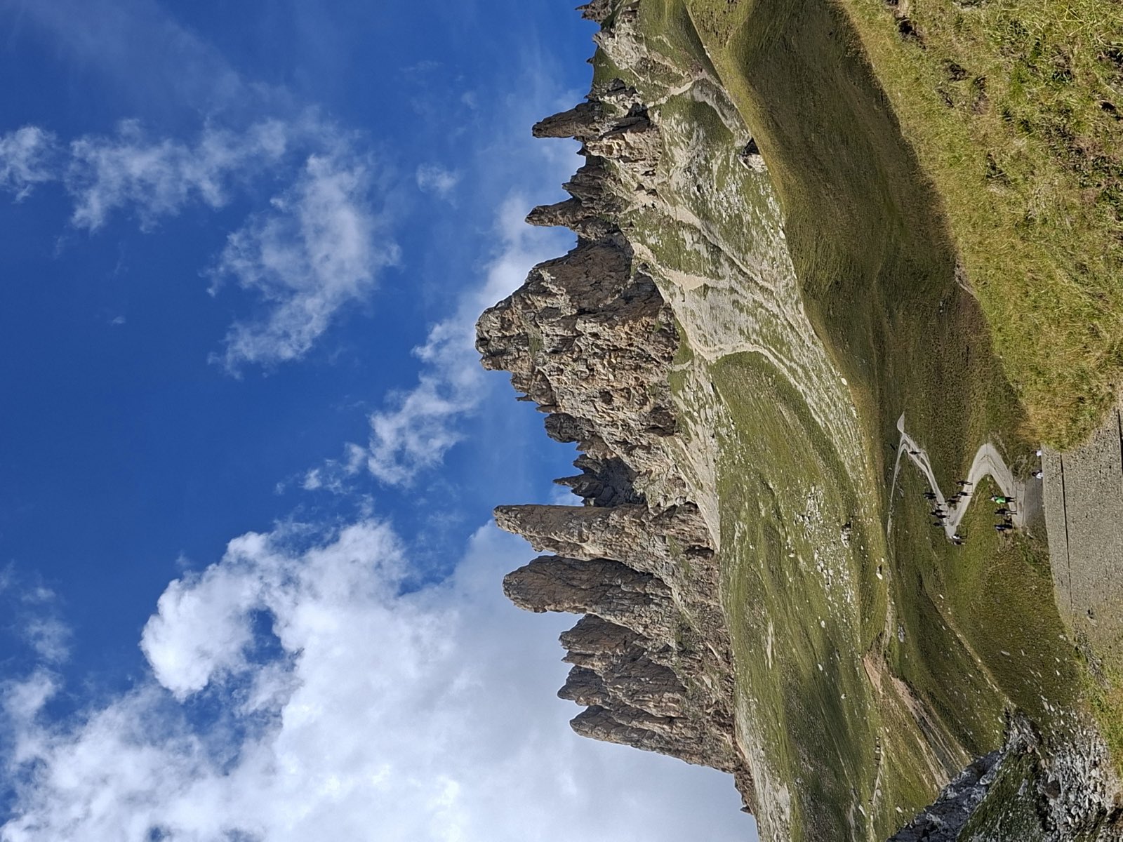
Sciliar e Denti di Terrarossa
South Tyrol's signature mountain: the flat-topped Sciliar massif, crowned by the twin towers of Santner and Euringer, with the jagged spires of the Denti di Terrarossa just beyond.

Sight · Val di Fassa
Val San Nicolò
The best-loved side valley of Val di Fassa: a wide green basin of meadows, farmhouses and waterfalls behind Pozza, where you leave the car at the entrance and walk in the quiet.
Huts
 2,440 m
 2,457 m2,243 m
Frequently asked questions
- When was the Schlern-Rosengarten Nature Park established?
- The Schlern area has been protected since 16 September 1974: it is the first of South Tyrol's seven nature parks. On 14 September 2003 the park was extended to the Rosengarten massif and since then it carries both names.
- How big is the Schlern-Rosengarten park?
- 7,288 hectares according to the Province of Bolzano fact sheet, the smallest of the four Dolomite nature parks in South Tyrol. It is shared between Kastelruth, Tiers and Völs am Schlern: Tiers puts 72 per cent of its own territory inside, Völs 44 and Kastelruth 20. The difference between its lowest and highest point is 2,156 metres.
- What is the highest peak in the Schlern-Rosengarten park?
- The highest figure the Province names inside the park is the Catinaccio d'Antermoia (Kesselkogel), 3,002 metres. The Schlern is lower: its highest point is Monte Pez, 2,563 metres, which the Seiser Alm board calls the Petz.
- How do you drive to the Seiser Alm and the Schlern?
- The Seiser Alm road is open to private vehicles only before 9 am and after 5 pm, and from 29 June 2026 an access permit is required at the St. Valentin checkpoint; driving down is free at any hour. The car parks up top, Spitzbühl and Compatsch, are booked online up to six days ahead. From mid-April to mid-May and from early November to early December the cable car is closed and the road is open all day.
- Can you camp in the Schlern-Rosengarten park?
- No. In the South Tyrolean nature parks overnight camping in a tent is forbidden, with the single exception of a mountaineering bivouac. The Seiser Alm tourist board adds that camping is allowed only at the campsite in Völs am Schlern, and that sleeping in a vehicle anywhere else is forbidden.
- Where is the visitor centre?
- In Seis, at Oswald-von-Wolkenstein-Platz 6, two minutes' walk from the bus station. The official page publishes its hours without a season: Monday to Saturday 8.30 am to 12.30 pm and 2 pm to 6 pm, in July and August also Sunday 9 am to noon, free of charge. There are also two information points, at the Völser Weiher and at the Steger sawmill in Tiers.
- Is the Latemar part of the Schlern-Rosengarten park?
- No. The Latemar belongs to the UNESCO system that carries all three names, Sciliar-Catinaccio and Latemar, but it lies outside the nature park, which covers Kastelruth, Tiers and Völs am Schlern. World Heritage and park have different boundaries.