
The Cadini di Misurina are the group of spires that forms the eastern backdrop of Lago di Misurina, in the municipality of Auronzo di Cadore. The highest peak is Cima Cadin di San Lucano, 2,839 metres. The Verona section of the Italian Alpine Club (CAI) describes it as a small group of modest height, but packed with towers, bell towers and pinnacles.
To the north it borders the Tre Cime di Lavaredo, to the east Croda dei Toni and Popera, to the south Val d'Ansiei, and to the west the lake and Cristallo. From Misurina you go up on foot or with the Col de Varda chairlift. In the group are the Fonda Savio and Città di Carpi huts, listed below, and trails that call for a sure foot.
On the map
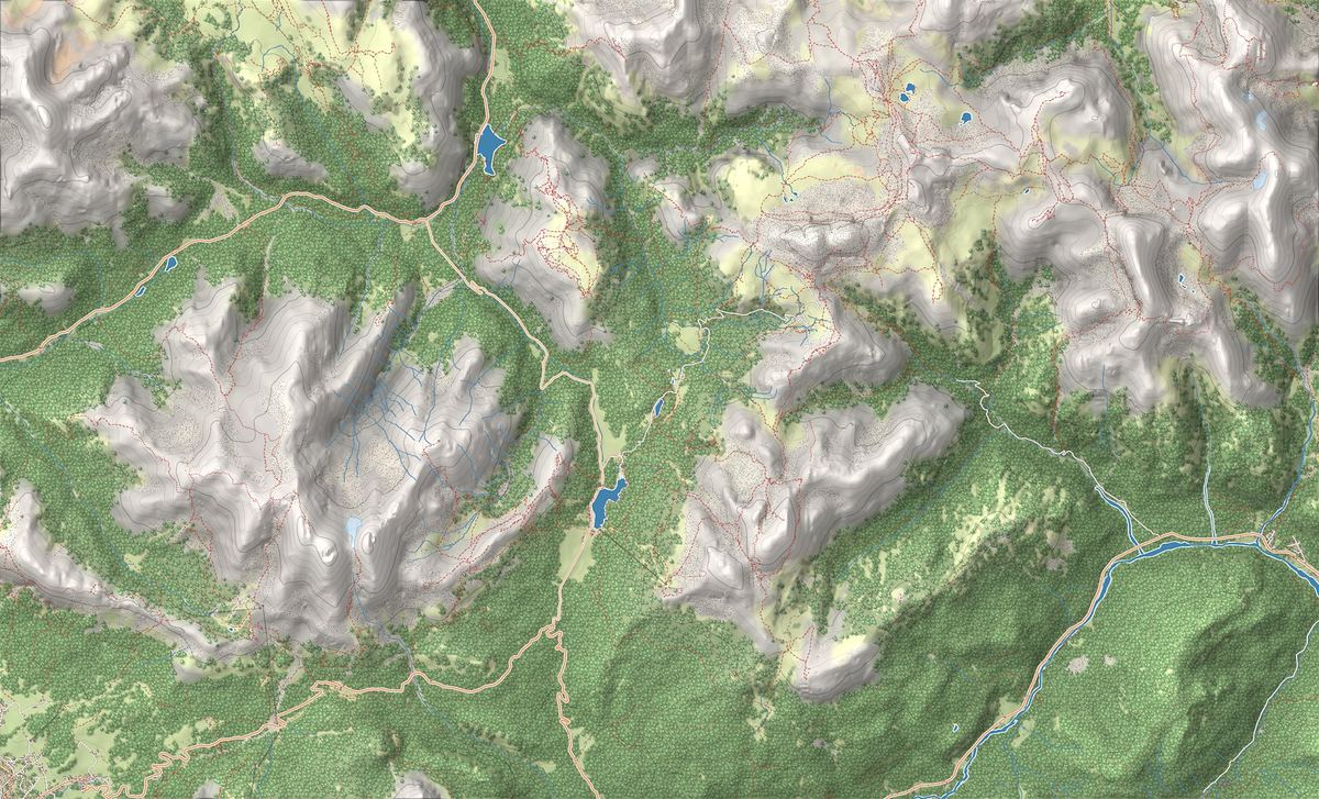
- 1Cadini di Misurina to Rifugio Fonda Savio: among the most cinematic spires
- 2Lago di Misurina Circuit: an easy stroll at the foot of the Tre Cime
- 3Rifugio Fonda Savio
- 4Rifugio Bosi al Monte Piana
- 5Rifugio Città di Carpi
- 6Lago di Misurina
- 7Cadini di Misurina
The best-known peaks
- Cima Cadin di San Lucano2,839 m
- Cima Eötvös2,825 m
Elevations from the map (OpenStreetMap).
How the group is built
The name comes from the Cadore dialect word ciadìn, basin: it refers to the cirques and hollows carved inside the group, the Treviso section of the CAI explains. Glaciers and weather have cut the rock down to towers, spires and pinnacles around these basins: for the CAI this is the most advanced stage in the evolution of dolomite rock.
At the foot of the group lies Lago di Misurina, which according to the Dolomites UNESCO Foundation was formed by a moraine lobe, the debris piled up by an ancient glacier.
How to get there
From Misurina the Col de Varda double chairlift rises from 1,756 to 2,106 metres, to the hut of the same name. From up there you see the lake with Cristallo, the Sexten Dolomites, Sorapiss and the Tofane. From Col de Varda trails lead into the group towards Rifugio Fonda Savio on one side and Rifugio Città di Carpi on the other; Rifugio Col de Varda is also a stopover on Alta Via no. 4.
On foot you start from the lake. Our hike to Rifugio Fonda Savio is a route for experienced hikers, with scree and exposed sections. The Cadini can also be seen well from the Tre Cime: the Auronzo and Misurina tourist board lists them among the groups visible from Rifugio Auronzo, at the end of the toll road.
Via ferratas, protected paths and climbing
The Auronzo and Misurina tourist board names two protected routes: the Bonacossa path, known for its exposed and scenic passages, and the Merlone via ferrata. It also warns that the group has unprotected routes that are technically demanding and need experience and a sure foot. For via ferratas you need a helmet, a harness and a certified via ferrata set: how to choose them is in our via ferrata guide.
For climbing, the Cadini are quieter than the Tre Cime: slender towers, good-quality rock and multi-pitch routes, in a less crowded setting.
According to the Verona section of the CAI, the highest peak, Cima Cadin di San Lucano, can be reached without real mountaineering difficulties, on an ascent almost entirely on snow. The hardest part is a steep gully, 200 metres high, leading to Forcella Alta, between Cadin di San Lucano and Cima Eötvös.
Names and UNESCO World Heritage
In Italian it is called Cadini di Misurina or gruppo dei Cadini. Tourist sites in German and English use the Italian name, while the Dolomites UNESCO Foundation writes Cadini-Gruppe in German.
The Cadini are part of the Northern Dolomites system of the UNESCO World Heritage Site, in the area the Foundation calls the Sesto-Cadini Dolomites, together with the Tre Cime; Val d'Ansiei separates it from the Cristallo group. The nine systems are explained on our Dolomites UNESCO page.
Trails in the group
 EE · Experienced hikers
Trail · Auronzo e Misurina
Cadini di Misurina to Rifugio Fonda Savio: among the most cinematic spires
3 h↑ 450 m7 km
 T · Easy / Tourist
Trail · Auronzo e Misurina
Lago di Misurina Circuit: an easy stroll at the foot of the Tre Cime
1 h↑ 20 m2.6 km
Mountain huts
 2,367 m
 2,205 m
 2,110 m
Things to see

Sight · Auronzo e Misurina
Lago di Misurina
The pearl of the Cadore: an alpine lake at 1,754 metres, known for the purity of its air, ringed by the Cadini peaks and a short drive from the Tre Cime.

Sight · Auronzo e Misurina
Cadini di Misurina
A forest of sharp spires, towers and pinnacles: dolomite erosion at its most extreme, and one of the most photographed subjects in the Dolomites.
Nearby
Places that fall inside the group’s frame but are closer to another group.
- Meridiana delle Dolomiti di Sesto
- Versante nord delle Tre Cime di Lavaredo
- Monte Piana e il museo all'aperto della Grande Guerra
- Gruppo del Popera e Croda Rossa di Sesto
- Tre Cime di Lavaredo Circuit: route, map and timings
- Monte Piana: open-air museum of the Great War
- Dobbiaco–Cortina Cycle Path: the great Dolomites railway trail
- Rifugio Auronzo
- Rifugio Locatelli
Frequently asked questions
How high are the Cadini di Misurina?
The highest peak is Cima Cadin di San Lucano, 2,839 metres, according to the Treviso section of the Italian Alpine Club. The other well-known peaks of the group are listed below with the heights from our map.
Where are the Cadini di Misurina?
In the municipality of Auronzo di Cadore, in the province of Belluno, just east of Lago di Misurina. The Tre Cime di Lavaredo lie to the north and Cristallo to the west.
How do you get up to the Cadini from Misurina?
On foot from the lake, or with the Col de Varda chairlift, which runs from 1,756 to 2,106 metres. From Col de Varda trails lead into the group towards the Fonda Savio and Città di Carpi huts.
Are there via ferratas in the Cadini?
Yes. The Auronzo and Misurina tourist board names the Merlone via ferrata and the Bonacossa protected path, with exposed passages. You need a helmet, a harness and a certified via ferrata set.
Are the Cadini trails suitable for everyone?
No. There is scree, exposed ground and unprotected routes that are technically demanding, so the tourist board asks for experience and a sure foot. Our hike to Rifugio Fonda Savio is graded EE, for experienced hikers.
Where can you see the Cadini di Misurina from?
From Lago di Misurina, whose eastern backdrop they form, from Col de Varda and from the Tre Cime area, already at Rifugio Auronzo.
Why are they called Cadini?
From the Cadore dialect word ciadìn, basin: the name refers to the cirques and hollows carved inside the group.