
The Sassolungo is the emblem of Val Gardena. Its main summit, 3,181 metres, gives its name to a group that the valley's tourist office defines like this: the Sella to the east, Val di Fassa and Val Duron to the south, the Alpe di Siusi to the west, Val Gardena to the north.
The name describes the shape: long rock in Italian, and the German Langkofel and the Ladin Saslonch say the same. Next to the main summit stand Punta Grohmann, the Cinque Dita (Five Fingers) and, towards the Alpe di Siusi, the Sassopiatto with its slanting flank.
The peaks with their heights, the huts, the routes and the passes on this site are listed further down, with the map.
On the map
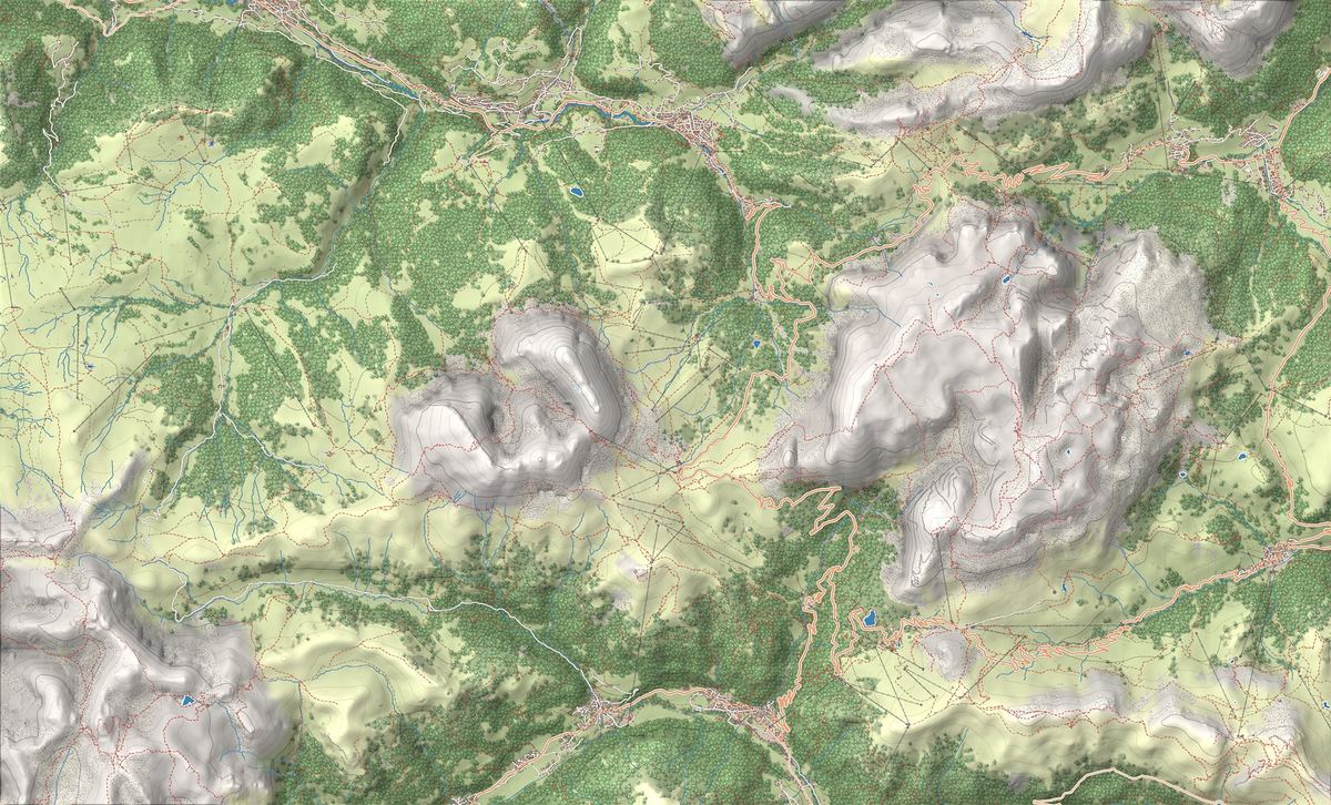
- 1Sassolungo Circuit from Passo Sella: the giant's loop
- 2Alpe di Siusi Circuit: endless meadows beneath the Sciliar
- 3Giro del Sassolungo
- 4Prati e malghe dell'altopiano
- 5Panorama sul Sassolungo e il Catinaccio
The best-known peaks
- Sassolungo3,181 m
- Punta Grohmann3,114 m
- Punta delle Cinque Dita2,997 m
- Sasso Piatto2,958 m
Elevations from the map (OpenStreetMap).
How it is built: an ancient reef
The Val Gardena tourist office presents the Sassolungo as a fossil reef. In the Middle Triassic this area lay under a tropical ocean, the Tethys: algae, sponges and corals built reefs up to 800 metres high, and the Sassolungo was one of them, shaped like a ring. The Sassopiatto is the reef's original sloping flank, still intact.
The Dolomites UNESCO Foundation adds that the Sassolungo and the Sella were Triassic islands, and that the Gardena and Sella passes were arms of the sea. Today the road over Passo Sella runs between the two groups.
Where to see it from and how to get there
From the Alpe di Siusi you see the Sassolungo and the Sassopiatto side by side above the meadows. Up there the road to Compaccio is closed to private cars from 9 am to 5 pm while the cable car is running, and since 29 June 2026 the car parks on the alp can only be used with a booking: the rules are in our Alpe di Siusi guide.
The base for the group is Passo Sella, between Selva and Canazei, on the border between Bolzano and Trento. From the pass a small gondola rises to the Forcella del Sassolungo, with its top station at 2,685 metres: Val Gardena says work began in 1957 and it opened two years later. Today it only runs in summer, in 2026 from 30 May to 11 October.
The car park at the pass charges a fee and in summer often fills up in the morning: the box below shows how often, and fees and alternatives are in our guide on where to park at Passo Sella.
What to do: the circuit, the summit, the climbs
For hikers the classic is the Sassolungo circuit, the loop that starts at Passo Sella and goes all the way round the Sassolungo by way of its notch; the gondola saves you the first climb. Val di Fassa also lists a second loop from the pass, around the Sassopiatto.
The summit is another matter. The normal route, Val Gardena writes, climbs the south-west face and the ridge; it is long and demanding, with more than 1,000 metres of height gain. Together with the Pichl route on the north ridge it is the favourite ascent for climbers who want to reach the top. Below the summit, at 3,100 metres, the Giuliani bivouac has stood since 1935, described by the tourist office as the first bivouac in the Dolomites.
History: from Grohmann to Comici
The Sassolungo was considered unclimbable, because of rockfall and the length of the ascent. On 13 August 1869 the Viennese Paul Grohmann set off from Ortisei with the guides Franz Innerkofler and Peter Salcher, reached the summit and planted a flag there. In 1875 a peak of the group that had never been climbed was named Punta Grohmann in his honour.
The Trieste climber Emilio Comici also left his mark on the Sassolungo: with Severino Casara he climbed the Salame, which the Italian Alpine Club lists among his routes that became classics. In a niche on the east face stands a 3.2-metre wooden Madonna by the Val Gardena sculptor Flavio Pancheri, placed there in 1961.
Sayings, legends and UNESCO World Heritage
In Val Gardena they say that when the Sassolungo wears a hat, the weather in the valley is fine. The cloud on the summit, the tourist office explains, forms when an air current is pushed up the mountain, and it only appears in stable weather. A legend tells that the giant Sassolungo, punished for his thefts, sank into the ground and left only his open hand outside: the Five Fingers.
The Sassolungo is not one of the nine systems of the Dolomites UNESCO site. The nearest is Sciliar-Catinaccio, on the other side of the Alpe di Siusi.
Trails in the group
 EE · Experienced hikers
 E · Hiking
Trail · Alpe di Siusi (Seiser Alm)
Alpe di Siusi Circuit: endless meadows beneath the Sciliar
3 h↑ 300 m10 km
Car park · Passo Sella
65/94
days the Passo Sella car park filled up
Recorded hourly from 01/06/2026 to 16/09/2026
Things to see
Sight · Val Gardena
Giro del Sassolungo
The classic loop around the Sassolungo, starting from Passo Sella and passing a string of historic refuges at the heart of the Dolomites.

Sight · Alpe di Siusi (Seiser Alm)
Prati e malghe dell'altopiano
The largest high-altitude meadow in Europe: 56 square kilometres of rolling pasture dotted with wooden barns and dairy huts, spread between the Sciliar and the Sassolungo.

Sight · Alpe di Siusi (Seiser Alm)
Panorama sul Sassolungo e il Catinaccio
From the plateau you get some of the best views in the Dolomites: the Sassolungo standing to the west and the long wall of the Catinaccio catching fire at sunset.
Nearby
Places that fall inside the group’s frame but are closer to another group.
- Vallunga
- Rifugio Pisciadù e ferrata Tridentina
- Sass Songher
- Sentiero del Viel del Pan
- Passo Pordoi e snodo del Sellaronda
- Via Ferrata Tridentina to Rifugio Pisciadù: difficulty and route
- Viel del Pan Trail: the balcony overlooking the Marmolada
- Snowshoeing in Vallunga: the snow-covered valley of Val Gardena
- Piz Boè Summit Route: the easy three-thousander of the Sella
- Via Ferrata delle Trincee: history and rock on the Padon Ridge
- Rifugio Pisciadù
- Rifugio Boè
- Rifugio Alpe di Tires
- Passo Pordoi
- Passo Sella
- Passo Gardena
Frequently asked questions
How high is the Sassolungo?
The main summit is 3,181 metres high, according to the Val Gardena tourist office.
Can you hike around the Sassolungo?
Yes. The loop starts at Passo Sella and goes round the Sassolungo, leaving the Sassopiatto outside: it is long, for fit walkers, and the Forcella del Sassolungo gondola saves you the first climb. Route and times are on the route page.
Where do you park for the Sassolungo?
At Passo Sella, where the circuit and the gondola start. The car park at the top has 199 spaces in summer and costs 4 euros an hour for the first three hours and 2 from the fourth, up to 20 euros a day. In summer it often fills up in the morning: the alternatives are in our parking guide.
Who first climbed the Sassolungo?
The Viennese Paul Grohmann, on 13 August 1869, with the guides Franz Innerkofler and Peter Salcher.
What is the Sassolungo called in German and Ladin?
Langkofel in German, Saslonch in Ladin. Both names, like the Italian one, speak of a long rock.
Is the Sassolungo in South Tyrol or in Trentino?
The group lies between the two provinces. Val Gardena and the Alpe di Siusi are in the province of Bolzano, Val di Fassa and Val Duron in Trentino. Passo Sella, where the circuit starts, is on the border between Trento and Bolzano.